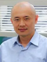
國立成功大學測量及空間資訊學系教授。研究專長為三維點雲建模、電腦圖學與數位幾何處理,並結合衛星遙測技術發展地理空間資訊之視覺化與分析,近年投入以光學衛星影像與類神經網路進行內陸水體水質監測之研究。
學歷背景
學經歷
- 2014~現在 國立成功大學測量及空間資訊學系 教授
研究專長
- 三維點雲建模
- 電腦圖學
- 數位幾何處理
- 地理空間資訊視覺化與分析
- 衛星遙測
研究成果與影響力
- h-index:23;論文總引用次數約 1,880 次;學術著作 106 篇、研究計畫 27 件。
- 近期研究聚焦以光學衛星影像結合深度學習,進行內陸水質(如葉綠素濃度)監測與輻射正規化分析。
Professor in the Department of Geomatics at National Cheng Kung University. His expertise lies in 3D point cloud modeling, computer graphics, and digital geometry processing, combined with satellite remote sensing for geospatial information visualization and analysis. His recent work applies optical satellite imagery and neural networks to inland water-quality monitoring.
Education
- Ph.D., Department of Computer Science and Information Engineering, NCKU (2004)
Career
- 2014–Present Professor, Department of Geomatics, NCKU
Research Expertise
- 3D Point Cloud Modeling
- Computer Graphics
- Digital Geometry Processing
- Geospatial Information Visualization and Analysis
- Satellite Remote Sensing
Research Impact
- h-index: 23; ~1,880 total citations; 106 scholarly works and 27 research projects.
- Recent research uses optical satellite imagery with deep learning for inland water-quality monitoring (e.g., chlorophyll concentration) and radiometric normalization.